OLD BRONX MAPS AND PHOTOS
Updated June 3rd, 2009.
Use the right and left cursor keys to shift maps back and forth.
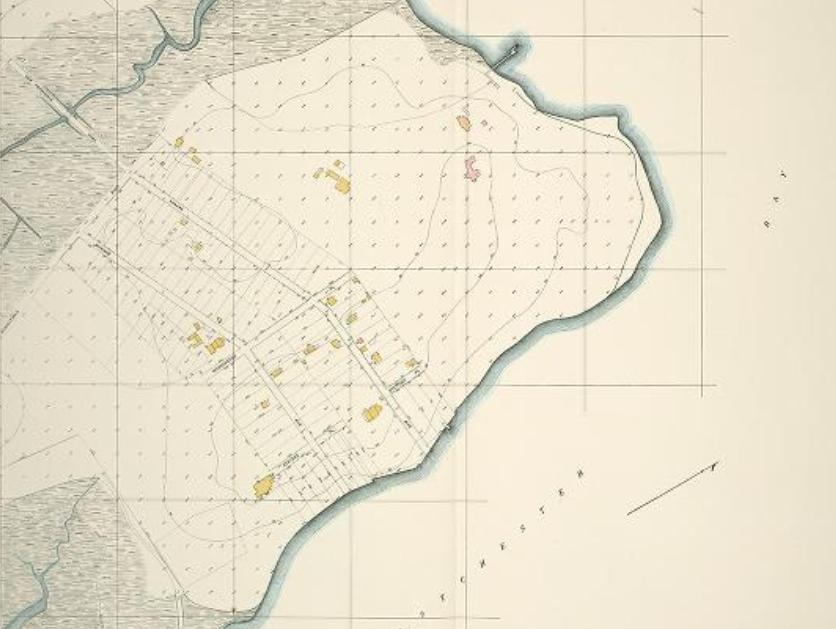
In this view, we see a long shot of the area, with Edgewater to the right.
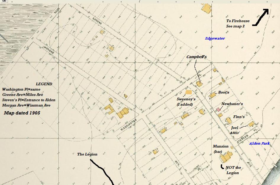
In this view, you can see the area outside of Edgewater and 1 house in Alden Park, namely the Attis' house (Port Attis). Click here for a photo of it.
In 1905, the date on this map, Miles Avenue was known as Greene Ave. and I once saw a construction map where Throg's Neck Bridge traffic was to come across the waterfront as Shore Drive and turn up Miles Ave. This might be one reason why the street is so wide. Old houses were allowed to keep their yards but new construction was set further back.


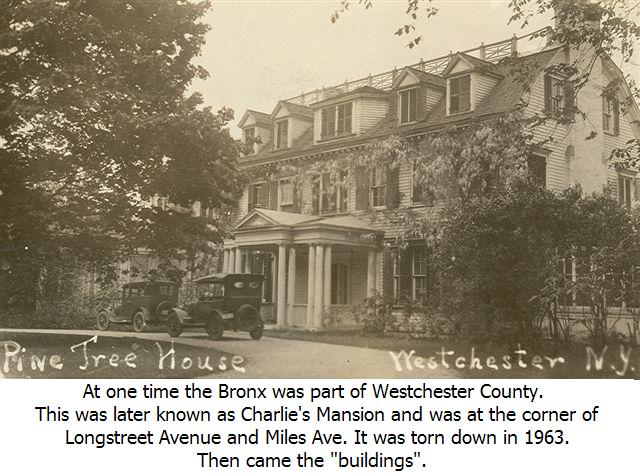
This view shows the area to the left, including the old Legion. At one time mansions dotted the landscape, surrounded by huge tracks of land, or estates. Click here for a photo of Charlie's Mansion.


In this view, the buildings of Edgewater are clearly visable, including the Firehouse and a few other buildings like the Edgewater Camp Barn. Click here for a picture of it.


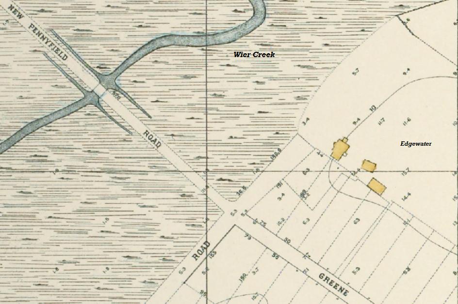
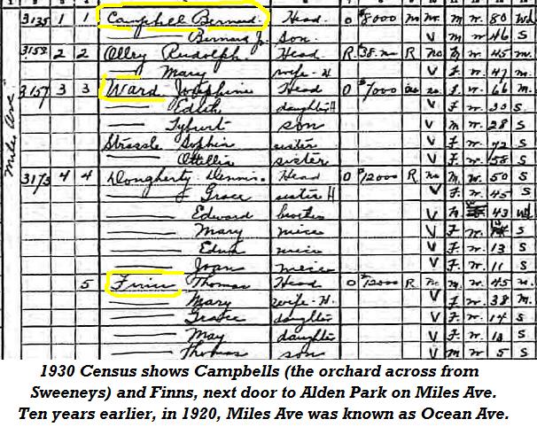
With more magnification and moving outward, we see the bridge over the south fork of Weir Creek. Greene Ave, where Campbell's orchard was, has changed names a few times. I know in 1920 it was called Ocean Ave and by 1930 it was called Miles Ave.
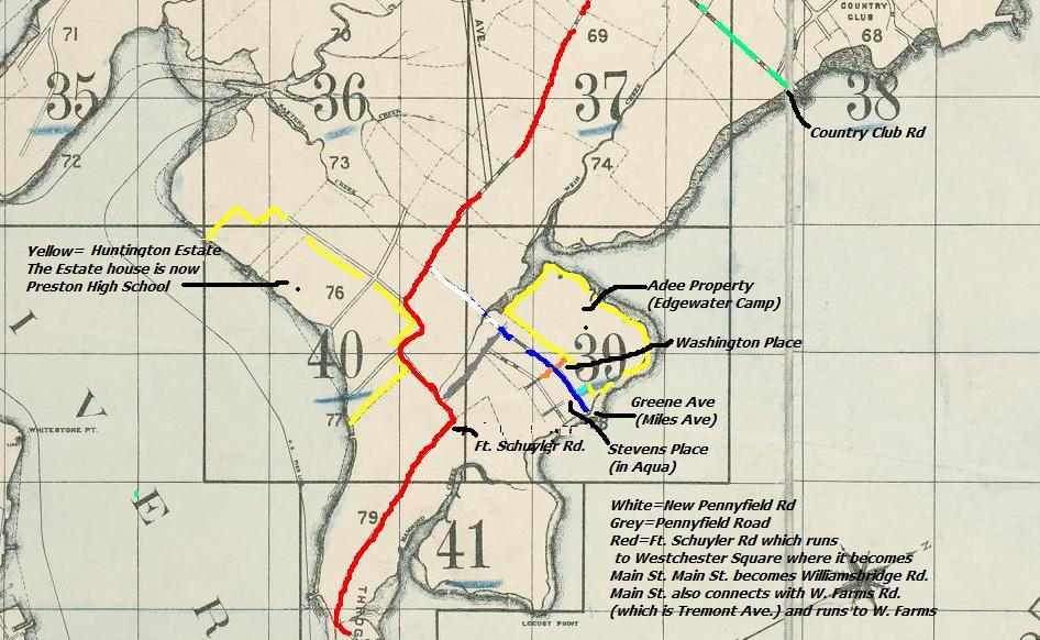
Map of Area shows among other things the Collis P. Huntington Estate (in yellow). This estate belonged to Shipping Tycoon and RR Magnate Collis P. Huntington, who it is said, could ride from the East Coast to the West Coast without leaving his own railroad tracks. The building is now Preston High School.

Many of the rich of the mid and late 1800's had estates in Throgg's Neck.

Below are 2 photos from 1957 for the proposed highways. Read the captions in each.

Run browser full screen and click on photo above, maybe twice, for larger view.
Don't forget to read the captions 1 to 4 on the bottom of the photo.
It's much easier to see if you follow the instructions in blue above.

Run browser full screen and click on photo above, maybe twice, for larger view.
Don't forget to read the captions 1 to 6 on the bottom of the photo. It's much easier to see if you follow the instructions in blue above.

As it is now. Look at how the bridge plaza was angled to the left as compared with the model above. Look at how small Locust Point was back then.
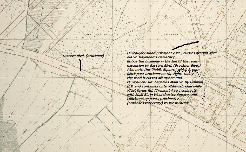
Bruckner Blvd. and Tremont Ave.
 Down to Westchester Square. Note the drawbridge on Tremont Ave. (Main St). Down to Westchester Square. Note the drawbridge on Tremont Ave. (Main St).
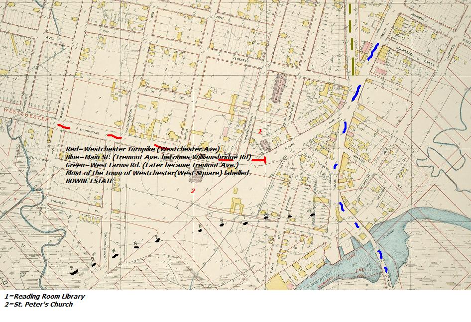
Note the blue lines above, lower right, as Tremont Ave. Westchester Creek runs beyond it, with swamps where Water's Place became after the area was filled in. Franklin became Blondell. Cooper became the Transit Train Yard. The heavier, straight lines were proposed new roads while the streets like Cooper were not part of the new street system and later disappeared.
Click on any picture with a border for large picture, then click on that picture.
The area around PS 72, which can be seen at center top, with E177th St (Cross Bx. Expwy) running at an angle past the church across from the school and Tremont Ave. crossing it. The construction at the bottom would become the projects at Balcom and Dewey Avenues.

The Bruckener Blvd. Bridge by Zerega Avenue. St. Joseph's is on the right beyond the creek.
Click on above photo, maybe twice, for larger photo.

Eastern Blvd. (Bruckner) at Westchester Creek near Zerega Ave. Photo - 20's.


Aerial view of Pelham Bay Park. Compare it with the map below this.

The hotel shown below and fields were located around where the dog run yard is now. That would be outside the wall where the Police stable is, halfway over to Pelham Pkwy.
Click on any picture with a border for large picture, then click on that picture.

Note what appears to be a swimming pool across the field from the stands, between the poles.


A close-up of the Park shows the boat house and bath houses at bottom center. All paths lead to the hotel pictured above. The bowling alley and lacrosse field were located in the woods across from the parking lot!

Baychester Ave. ran from the train station (now Co-Op City) over to the Park, crossing Pelham Pkwy.

The Tallapoosa Club had everything. Now it's Mount Trashmore, the city dump open in the 70's.

A long shot, showing the old layout of the Park.

The proposed street grid. The map is from 1906.
Click on any picture with a border for large picture, then click on that picture.

This trolley ran up and down Westchester Ave. Note poles above it for drawing power from overhead wires.

This trolley ran up to Eastern Blvd. (Bruckner Blvd.).

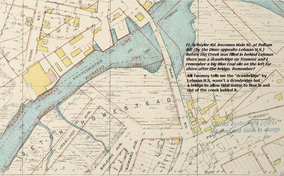
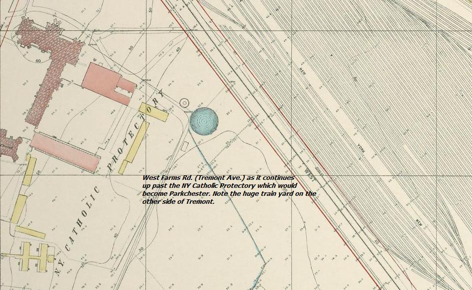
Follow the train tracks where they make the left into the train yard. Beyond them you can see the water, part of the creek that was later filled in at Water's Place. Lehman HS and all land west of it was originally the creek with a bridge on Tremont Ave. in front of Lehman HS.

Looking towards Williamsbridge Rd. These stores are 2 doors down from Woolworth's.

Now a memory. Woolworth's. Remember how the floors sloped down from the rear of the store to the front?

Frisby Ave. in the late 30's.

Frisby Ave. now.

Click on any picture with a border for large picture, then click on that picture.

The corner on the right would be the Square Diner.

The old Square Movie Theatre, which became XXX in the 60's. This diner on the end was a popular morning spot for people going to Christopher Columbus H.S. They was torn down in the late 70's to make way for the tall Con Ed building.

The old courthouse at 1400 Williamsbridge Rd. - now used for parking tickets.

1416 Williamsbridge Road.

1418 Williamsbridge Road.

1424 Williamsbridge Rd. This corner store became the Locksmith on Williamsbridge Road. Note the "daisy" type street light that Edgewater had up into the late 60's.

1500 Williamsbridge Rd. This later became a gas station. The Firehouse is next door.

Here's the gas station. Hotch Acker worked here - Photo late 60's.

1473 Williamsbridge Road.

Tremont Ave at the split with Williamsbridge Road.

Pape Chevy was on the bend heading up Tremont Ave. out of the Square.

Photo from the mid 60's.

Jack's Diner, which was around for decades is gone now.

Rota's Restaurant -Tremont and Castle Hill Avenues

Click on above photo for video.
A short video narrated by James Earl Jones about Frank Bee Stores & it's owner Wayne Baker.

2980 Bruckner Blvd.

Eastern Blvd. (Bruckner - left to right) before the highway. Photo late 50's.

The old and the new schools - P.S. 14.

Later on it's looking old.

The original PS 14 with a landscaped entrance.

3489 East Tremont Ave.

The Interboro in 1970. Back in the 30's and 40's it was known as the "Itch " due to infestation.

Ft. Schuyler Pharmacy

Click on any picture with a border for large picture, then click on that picture.

3756 E. Tremont - The Randall Tavern.

3762 E. Tremont

3483 E. Tremont - Later became a Bar.

If you look down at the end of the street, there's an old mansion blocking the street. See below.

The old J.D. Wolfe mansion was in the middle of the street when they cut the streets through.


The Poor Clare Monastery - Now replaced with condos after being totally demolished.
Pelham Parkway 1928 - Note windowless buildings just being built.
Tremont Avenue and Castle Hill Avenue

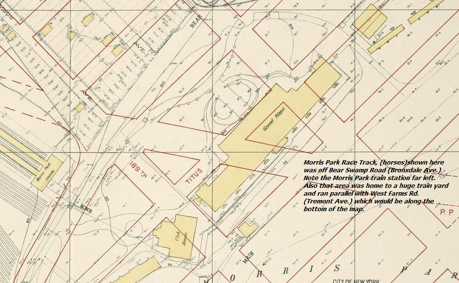
Tremont Ave. and Bronxdale Ave. (Bear Swamp Road). Across from the Morris Park Train Station was the Morris Park Race Track.
Bronxdale Ave. further up off Tremont Ave. and the Morris Park Race Track.


The Morris Park Race Track


You can see the Grand Stand to the left. Behind it was Bear Swamp Rd, now Bronxdale Ave. Way off in the distance, slightly left of center is St. Raymond's Church beyond the railroad tracks and West Farms Rd. (now Tremont Ave.)

You can also see the way they closed off sections of the track. Compare with photo above. Prior to them carving new streets through here around 1911 or so and after the horse track wasn't used anymore they used it for racing cars. Mr. Chevrolet was supposedly one driver and then they even used it for airplanes.


The Race Track was sold and divided up into streets around 1911.

Here you can see the beginning of the end for the Morris Park Racetrack.

This area would become the Van Nest neighborhood.

Here you can see the new streets being put in.


An enlarged photo of the one above. The sign on the shack says Morris Park.
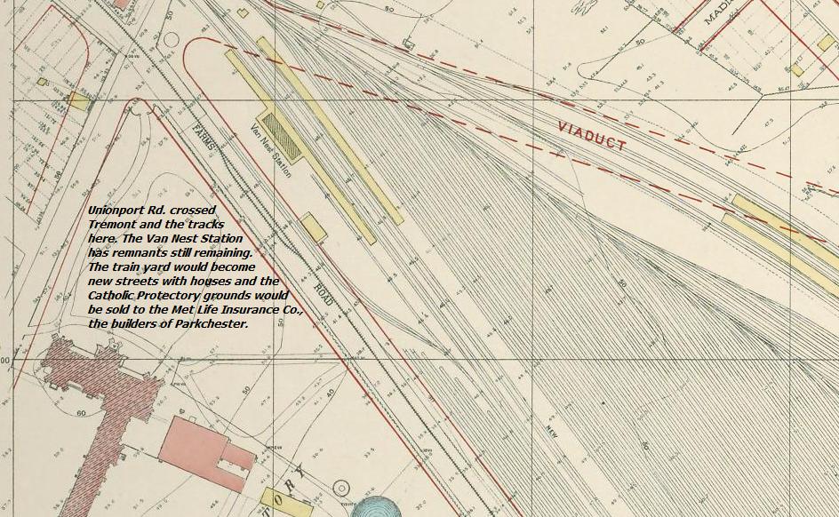
Note the incredible amount of train tracks located behind the old Motor Vehicle building on Tremont Ave. that ran from Bronxdale (Bear Swamp Road.) up to Unionport Road.


The Bruckner Expwy looking North towards the Bronx River Parkway interchange - Photo mid 60's.
What's really interesting to me is the lack of dividers. People drove around with cars that were much heavier and had poorer brakes than now. People paid attention back then. If you caused an accident, chances are people called you a moron as they passed by. There were no seatbelts either. Kids always rode in the front. At least I did.

Bruckner Blvd. before it was elevated past the drawbridge.

How it was supposed to look. The Bx. River Expwy. became the Sheridan Expwy.and was elevated to connect with the elevated Bruckner Expwy. Note further up where the roads join, just beyond the triangle shaped building is the entrance of the el into the subway tunnel.


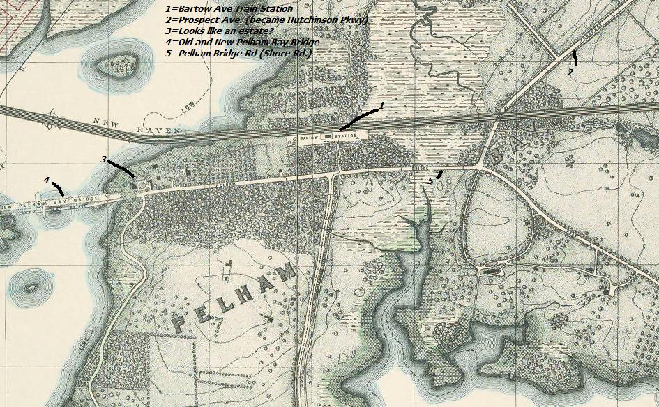
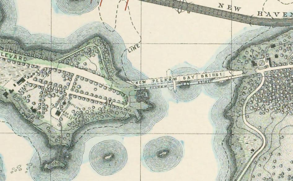
Heading out to City Island, which you could get to by Eastern Blvd. (Bruckner) or Pelham Pkwy. From the Bartow Train Station was a short lived Monorail System that ran out to City Island.
The Tallapoosa Club would be at present day "Mount Trashmore" (the city garbage dump) which was open throughout the seventies.

The monorail which ran from the Bartow Ave. railroad station out to the City Island Bridge.

The interior of the monorail.

more to come
|


